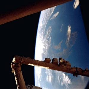
I’m not sure where this photo came from originally (beyond space, that is). It was passed on to me via email and I thought it might serve those who don’t know where Acts of Volition lives and be of interest to those who do. If anyone knows the origin of the image, please let me know.
The pointed-crescent-shaped island roughly in the middle of the photo is Prince Edward Island, our island province of Canada. Our Island is wrapped by Nova Scotia and Cape Breton on the south and the east. New Brunswick, Québec’s Gaspe Penisula, and the mouth of the St. Laurence river frame us from the west and north-west. In the top right you can see the south-western tip Newfoundland.
For those that still aren’t oriented, Boston would be somewhere near the center of the very bottom of the photo.
I suspect those arms in the foreground are those of our soon-to-be robot overlords.

This probably doesn’t help too much, but I originally found it here.
Apparantly it was posted by the administrator of PEIinfo.com
I guess you could always give him a shout. He might know a bit about it.
This is going as my windows wallpaper..
That’s a fantastic photo, thanks for posting it.
Whenever trying to explain where PEI is to someone from far away, I usually say “It’s an island north of Halifax.”
I know that’s terrible geography, but it seems to work; methinks because Halifax is a big port.
Fantastic picture Steve. Could that possibly be the new version of the Canadarm, the multi-jointed wormlike one?
It should be noted, I believe, that the image appears to be somewhat distorted, showing the eastern part of the island as being much much larger than the western part. Also, Cape Breton Island looks like it’s much bigger than it is in relation to PEI.
On a recent JetsGo flight from Charlottetown to Toronto, our aeroplane flew up and looped around a couple of times and then headed out almost parallel to Rte. 2 to Summerside. By the time we got over CFB Summerside, we were high enough that we could see both West Point and North Cape in one view out the window. Which means, I think, both that we were pretty high, and that the Island is pretty small.
Here are some additional NASA images of Prince Edward Island:
Well, the photo is obviously a warning from one of the aforementioned robot overlords, possibly a member of a rebel robot overlord coalition, seeking to overthrow the robot overlord way of life and form friendly relations with the people of Earth. Heed the rebel robot warning! Prepare the ion cannons!
Steve – a friend emailed this photo to me while I was living in Australia and mentioned that it was the Canadarm in the photo. As for where it came from… ?
*Everyone* knowns that the moon landing pictures are obviously fakes since there are no stars in it. Oh wait, this picture – and most any space picture – don’t show any stars in it either.
I guess these pictures are fakes as well! 😛
Ya they are fake. I photochopped them….Not really…
Please disregard my earlier post. After looking at other photos, it does seem that the eastern part of PEI is that much bigger than the western, and that Cape Breton is that much bigger than PEI.
Maybe you’ve been Boomified, Rob. Prioro to Canada Now, Boomer’s map showed PEI about 50% bigger than it really was compared to the rest of the Maritimes. The western tip was up by Gaspe and Souris almost north of Cheticamp.
Ah, nothing like a great fake space picture.
As for this picture, as well as the one’s linked by Mr Rukavina, all one can say is – Awesome.
I’m amused by the little robot pigeons roosting along the lower strut.
hello i,m amr from egypt i hope to give me many information and pictures to my e mail