Prince Edward Island’s Department of Agriculture and Forestry has photographed every inch of the Island from about 9000 feet. The provincial government website has combined these photos with their powerful mapping plugin to make for an amazing way to view the Island.
You’ll need to download the Autodesk MapGuide plugin and the browsing can be slow (it’s always “requesting dynamic map layers”) and the images are large (between 150Kb and 200Kb each) but it is worth it.
See the photos »
Note: You have to double click on the photo dots to open the images.
Big ups to Peter at Reinvented for this.
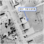
When were the pictures taken?
I guage about a year or so ago, because the old West Royalty school was still there, but the initial demolishing of the portables was taken care of.
Which leads me to believe that the car in the picture was either Steve’s Volvo (bananawagon) or the ill fated Fox.
Or Doug’s minivan, it’s just a dot. With a fine looking underbelly, however.
Observant Rob. It looks from some construction that the photos may have been taken last summer.
So yes, it wouldn’t have been my toyota, nor would it be my flaming VW Fox, or my borrowed 1978 Volvo of death. Rather, it would have been my 1999 CCM Ice, Chrome.
The photos must be as recent as late last Fall. The house built next to ours in November is in the photo so that provides a clue.
Just a note to let you know that by summer’s end we’ll have digital versions of the 1935 and 1974 aerial surveys of the Province at http://www.gov.pe.ca.
Why not give the commies some more help while your at it; just put a big red target on my house? Throw a little tooltip on it that says “fascist”… They’d love that.
Now, where is area51 exactly? I’ll get those suckers. One at a time.
If the commies don’t get me first.
Jevon, I’m way ahead of you.
Groom Lake (aka Area 51) can be found at 37.23N 115.83W.
I spent my years at OLS as as frustrated conspiracy theorist and I enjoyed nothing more than inspecting satelite pictures of the Groom Lake compound for small, blob-shaped aliens.
I found none. Now, I search for Pokémon. Curse that Pikablu.
As promised, the 1935 arial photo survey photos are now up at http://www.gov.pe.ca.
Nice work.